|
We introduce Handwork, traditional crafts, folk art and traditional foods
made by craftsmen in the Tohoku region of Japan ,
that have been handed down from generation to generation,
and sell them by mail order .
・・・We advocate Life with Japanese beauty.・・・ |
 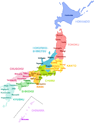 |
- The Tohoku region is one of the regions of Japan and is located in the
northeastern part of Honshu.
- Also known as the "Ou region".
- Although there is no clear legal definition of its scope, it generally refers to the six prefectures of Aomori, Iwate, Miyagi, Akita, Yamagata, and Fukushima.
- These six prefectures cover an area of about 30% of Honshu.
- Although the Tohoku region is located in eastern Japan, it is considered
Northern Japan along with Hokkaido in meteorology and historical geography.
|
|
|
Topography of the Tohoku region □Return
-
According to plate theory, the Tohoku region, along with Hokkaido, lies on the North American Plate, with the Pacific Plate submerged in the Japan Trench from the east.
As a result, there are many earthquakes, mainly sea trenches, and sometimes large earthquakes of magnitude 9 or greater, such as the Tohoku Pacific Offshore Earthquake (the Great East Japan Earthquake).
The Nasu volcanic belt runs from north to south parallel to the Japan Trench in the center of the Tohoku region.
On top of this volcanic belt, the Osorezan Mountains of the Shimokita Peninsula and the long Ou Mountains run from north to south, and there are many volcanoes such as Osorezan, Mt.
Above the Nasu volcanic belt (Ou Mountains), there are caldera topography such as Towada Lake, Tazawa Lake, Onikobe Caldera, and the area around Mikama in Zao, and there are many hot springs that are a benefit of the volcano.
Lake Inawashiro is a fault lake.
-
On the Sea of Japan side, the boundary between the Eurasian and North American plates runs from north to south, and the Chokai Volcanic Belt runs parallel to the Nasu Volcanic Belt from north to south.
The Shirakami Mountains, the Dewa Mountains (Taihei, Asahi, and Iitoyo Mountains), and the Echigo Mountains are located at the top of this volcanic belt, and the volcanoes with beautiful ridgelines such as Mt.
Where the mountains meet the sea, there are hot springs along the coast
where you can take a bath with a view of the sea.
-
On the Pacific side are the Kitakami Mountains and the Abukuma Highlands. These are rolling, low mountainous areas that have been eroded by uplifted topography and are now senescent.
Hayatechibine, 1917m above sea level, is one of the remaining hills in the area, but it is basically a gentle mountain area with less snow than the Ou Mountains on the Sea of Japan side, so there are no ski resorts, and since it is not a volcanic zone, there are few hot springs.
However, there are many limestone formations, such as limestone caves,
which are evidence of uplift from the sea floor in the past.
The Kitakami Mountains jut out into the sea on the rias-type coast of Sanriku,
where the limestone rocks were washed away by the waves to create a complex
coastline and white sandy beaches that contrast with the cobalt blue sea
of the parent tide.
The area between the Abukuma Highlands and the Pacific Ocean is a detached coast, with small alluvial plains that seem to have been reclaimed by the sea between the rias-type coasts, alternating with small high mountains.
-
The Kitakami River, the Abukuma River, the Oumono River, the Mogami River,
and other rivers flow between these three north-south mountain ranges and
mountains, creating many basins and plains.
-
The climate, although modified by small topography, is broadly divided into four groups, each with different trends: the Japan Sea coast, the foot and west side of the Nasu volcanic belt (basin), the east side excluding the foot of the Nasu volcanic belt (basin), and the Pacific coast.
There are also subtle differences between the north and south for each group.
With the exception of the Pacific coast of Miyagi and Fukushima Prefectures, the entire area is covered by heavy snowfall, with some exceptionally heavy snowfall areas.
-
The Japan Sea coast and the "Japan Sea side group" at the foot of the Nasu Volcanic Belt and the west (basin) has a Japan Sea side climate, with many sunny days and very high temperatures in summer (40.8°C in Yamagata City) due to the fawn phenomenon.
However, despite the high temperatures during the day, it is easy to spend the night with cooler temperatures.
In winter, there are few hours of sunshine and heavy snowfall in many parts of the country, but the snowfall is particularly high in the basin west of the Ou Mountains.
-
The eastern side (basin), except for the Nasu volcanic belt and foot of the Pacific Ocean side, has both a Pacific side climate and an inland climate.
During the summer months, there are both hotter days due to the fane phenomenon and cloudy, cooler days, such as those in the Pacific coastal region.
In the winter, when the cold air masses, northerly and westerly winds and
other factors are strong, snow can fall, as on the Sea of Japan side, while
there are many sunny days, as on the Pacific coast.
-
The Pacific coast has both a Pacific side climate and an oceanic climate.
During the summer months, the northern and central parts of the country are usually cloudy and temperatures do not rise, and every few years there is a cold summer with low temperatures and bad weather due to the influx of Yamase.
In the southern part of Hamadori, Fukushima Prefecture, the summer season is often hot and sunny due to the influence of the Pacific high pressure.
In the central and southern parts of the country, the winter snowpack is low, and the air is clear and dry.
Introduction to History □Return
-
Under the ritsuryo system and centralized control of the Kinai regime, Dewa was considered a coastal country (reachable by boat and close to the Kinai area) beyond Echiguni (Hokuriku Province), and Mutsu was considered a landlocked country because it was reached by foot on the Higashiyama Road.
Therefore, in the era when there were no surveyed maps like today, Dewa was regarded as a map of the political forces along the Sea of Japan coast and Mutsu as a map of the political forces in the backlands of Honshu, and their boundaries changed according to the rise and fall of the political forces in a place and were not necessarily neatly divided into east and west by the Ou Mountains.
After the Kamakura period, when the Ezo (captive power) receded, Mutsu
became closer to Kamakura, which was in power, and since Kamakura and Dewa
were not connected by ship, the meaning of Dewa as a coastal state diminished,
and the two states came to be called "Oshu" together.
-
However, because they are close to the various governments in the Kanto region (Kamakura Shogunate, Edo Shogunate, and Meiji Government), they tend to be more subordinate to the regime.
After the Meiji Restoration (1868-1912), the city lost many of its intellectual warrior class to the migration to Hokkaido and Tokyo, and the Nobiru Port was closed after two years due to a typhoon, making it the only region without an open port.
In addition, until the early Meiji era (1868-1912), when the land tax was
revised, the penetration of the money economy was slower than in other
regions, and it was less important as a domestic market.
-
Now that the population has grown and highways have been developed, land transportation is being reorganized and an economic zone is being formed within the Tohoku region.
At the same time, the population is concentrated in the Sendai metropolitan area and other areas are becoming depopulated.
-
The Paleolithic period was influenced by the glacial period and was colder than it is today.
As a result, little is known about life on the coastline at that time, as it was further offshore than it is now, and is now submerged in the ocean floor.
We can learn more about inland life at the Tomizawa and Kanatori sites
in the Tohoku region, but some other sites from the Early Palaeolithic
period have been returned to the drawing board due to the Paleolithic fabrication
incident, so we are currently working on verification.
-
It is believed that the climate warmed up during the Jomon period and that the Tohoku region was warmer than it is today during the middle Jomon period.
At that time, the lifestyle centered on gathering, hunting and fishing was more suitable for eastern Japan than western Japan, and the Tohoku region, along with the Kanto and Central Highlands, is known as a region with a high density of Jomon period remains.
Compared to the Kinki, Chugoku, and Shikoku regions, which had the lowest population densities, the Kanto region, which had the highest population density, had more than 30 times as many people, and the Tohoku region had 5 to 10 times as many people.
As a result, the ruins of Sannai-Maruyama, a huge settlement that lasted for 1440 years, and primitive Jomon farming, such as chestnut cultivation, began here, and it played a central role in Jomon culture along with the Kanto and Central Highlands.
-
The Jomon culture declined due to the cold of the late Jomon period, and by the end of the Jomon period, paddy rice farming was introduced from the continent, and the Yayoi culture developed mainly in western Japan, including northern Kyushu and the Kinai region.
The Yayoi culture spread relatively early in the Tohoku region as well, and paddy rice farming is thought to have been introduced in the early Yayoi period.
However, generally speaking, paddy rice farming was not fully accepted until around the latter half of the middle Yayoi period, which is thought to be around A.D.
Some believe that it was a continuation of the Jomon culture in the north.
In the south, too, the abandonment of rice cultivation and the southward
movement of the Jomon culture can be seen.
-
During the Kofun period, the Kofun culture arrived from the Kinai region, and Kofun tombs were built in the Tohoku region as well.
Kofun tombs are concentrated in the southern part of the Tohoku region, including the Sendai Plain, the Aizu region, and the interior of Yamagata Prefecture.
In addition, an anterior and posterior round burial mounds, which are thought to have originated in the Nara basin, were built, and it is thought that the interaction with the Yamato royal family had already begun.
The largest forward and backward round burial mound in the Tohoku region is the Burial Mound of Raigamiyama in Natori City, Miyagi Prefecture.
Late Kofun tombs are distributed in northern Miyagi and Akita prefectures (one theory is that the Shonai region in Yamagata Prefecture is included).
In the northern Tohoku region of Aomori Prefecture, a continuous Jomon culture has persisted, and kofun tombs are limited to small, terminal-period tombs.
-
In ancient times, the relationship between the Yamato dynasty and the powers
of the Ouagoshi region (Tohoku and Niigata prefectures) gradually shifted
from the level of a loose regional union until the Kofun period to a centralized
relationship between capital and region.
-
The ancient Tohoku region and the areas east of Yoneyama Pass in Niigata Prefecture (Chuetsu, Shimoetsu, and Sado Island) were "unconquered" from the perspective of the Kinai regime, and were believed to have been inhabited by "emishi," a different race of people who did not submit to the Kinai regime (there are various theories as to the extent to which the emishi lived).
Since then, from ancient times to the Middle Ages, the history of the Tohoku region has been made by the clash of the war of conquest on the part of the Kinai regime and the independence or semi-independence of the Tohoku region (especially Okuroku-gun).
-
From the middle to the latter half of the 7th century, when a powerful
bureaucracy led by the emperor came to be desired, the national system
changed drastically from the decentralized system, which had been ruled
independently by the local Australian clans as a nation building, to a
centralized system.
-
In the middle of the 7th century, in the Pacific Ocean, from present-day Fukushima Prefecture to the central part of Miyagi Prefecture, as well as the southern (Okitama-gun) and central (Mogami-gun) parts of Yamagata Prefecture, were subjugated to the Kinai regime and separated from Hitachi Prefecture to form Michinoku (Michinoku). (later, Mutsukuni) was established.
This is an area where a number of front and rear round tombs were built during the Kofun period (Miyagi Prefecture was settled in the 7th century).
-
On the Sea of Japan side, the allied forces of the Yamato Kingdom and the Koshinokuni, which had already conquered as far as the Joetsu region (Kubiki-gun) in Niigata Prefecture, moved northward while establishing a front-line base called a "fence.
Firstly, Nutari fence (current Niigata city center) was installed in 647 (3rd year of Taika), and then in 648 (4th year of Taika), Banshu fence (current Iwafune county, Murakami area) was installed, and the Japan Sea coast was incorporated into the Etuguni.
In 658, in the 4th year of Emperor Chimei's reign, Abehirao, who was the governor of Koshiguni, led 180 warships further north along the coast of the Sea of Japan to "Aganita no Ura" (around the present Akita City?). It reached the Tsugaru region (Nihon Shoki).
There is no definite answer as to whether this was the Ezo expedition or an armed trading fleet. At least this Abe naval force was in the 4th year of Emperor Saimei's reign (658)
- During the 6th year of the Emperor Saimei's reign (660), he made three trips to trade and return.
Later, Baekje, who was allied with the Ginae regime, was invaded by Silla, so the Abe naval force joined the battle line and the expedition to the northeast Sea of Japan was halted.
-
With the development of the ritsuryo system and the establishment of a centralized state, the development of local control systems also progressed.
The Imperial Court troops moved northward to reach the Shonai region and set up a fence at the mouth of the Mogami River in present-day Sakata.
When Koshinokuni was divided into three countries, Echizen, Echizen-Chugoku, and Echigo, Dewa-gun was established in the Shonai region on September 28 of the first year of Wado (November 14, 708), and was incorporated into Echigo.
Dewa County was separated from Echigo Province on September 23 of the 5th year of Wado (October 27, 712) to become Dewa Province, and later, Okitama and Mogami Counties were transferred from Mutsu Province, and Dewa Province, which had been a coastal province, was given the inland area (it is thought that the kokubu was set up at the ruins of the castle ring fence in the northeastern part of present-day Sakata City).
-
After the Ezo rebellion in 720 (Yoro 4), Taga Castle was built on the northeast Pacific side in 724 (Yoro 8), and the southeast and north were fully incorporated into the ruling system of the Imperial Court.
In 733, the Imperial Army moved the Dewa Fence to Akita Takashimizuoka (the remains of the present Akita Castle).
In 737 (Tenpyo 9), an access road from Tagajo to Dewa Fence was cleared by Ohno Tojin.
-
In the northern northeast, the Kitakami River basin in present-day Iwate Prefecture (Okuroku County, Hidakami Province) and the Yokote Basin in Akita Prefecture, which is separated from the Great Pacific Ocean by the Kitakami Mountains and is also far from Tagajo, remained as areas of Ezo influence, and the subsequent conflict with the Imperial Court (Tagajo) continued.
-
In 780, during the reign of Emperor Kōnin in the 11th year of of Houki (780), Ijiyūen-aro revolted and took Taga Castle.
In the Heian period (794-1185), Emperor Kanmu made three peacees with the Emishi, and Tamuramaro Sakauei became the great general of the Emishi army and won the battle against Aterui.
Defeated, the Ezo army was captured in a vow of submission to the Imperial
Court, and some were forced to migrate to other parts of Japan.
-
Once the rule of the imperial court was established, a large number of
settlers from the Kanto and Hokuriku regions came in (fence doors), and
the internalization of the Tohoku region progressed.The Abe clan grew in
power from within the captivity of the Tokugawa Shogunate, and from their
stronghold in Okuroku County, they gained influence over a vast area from
Nukabu (in present-day eastern Aomori Prefecture) to Watari and Igu (in
present-day southern Miyagi Prefecture), but they were destroyed in conflict
with Minamoto no Yoriyoshi (9th year before the war).After that, the Kiyohara
clan gained power, but this was also destroyed by the Minamoto no Yoshie
(the third year after the war).
It is argued that through these two roles, the two regions, previously
recognized as Mutsu (the eastern end) and Dewa (the northern end), were
brought together.The imbalance of only two of Japan's sixty-odd states
in the vast region of the northeastern part of the country really lasted
a long time until the Meiji Restoration, but this was partly due to the
transition of government to the samurai family and the complete demise
of the branching system, and partly because the population density and
productivity of the northeastern part of the country were not much lower.
According to Taikoo's survey, Mutsu's stone height is already six times higher than the average of other countries, and Dewa's is about twice as high.
-
From the end of the Heian Period to the beginning of the Middle Ages, the Oshu Fujiwara clan flourished in the Kitakami River basin (Okuroku-gun), and Hiraizumi developed into the second largest city in Japan after Heian-kyo.
The Oshu Fujiwara clan is thought to have amassed a fortune by collecting taxes from the imperial domains of both Mutsu and Dewa and from the manors of the Setseki family.
However, when Minamoto no Yoshitsune was sheltered, he was attacked by the Kamakura government and destroyed by Minamoto no Yoritomo.
-
The Hojo clan's territories were set up widely, but some of the powerful clans, such as the Ando clan in Tsugaru region, which were regarded as lords in a place of residence, maintained their power.
The Ando clan is said to have been appointed by the Hojo Tokumune clan as the Emishi deputy and to have ruled Hokkaido from the northern northeast.
Jusaminato, the stronghold of the Ando clan, prospered through trade and became one of the leading cities in Japan.
However, in the Muromachi period, the Ando clan was forced to leave Tsugaru
and move to Akita due to the conflict with the Nanbu clan, and the prosperity
of Tosaminato was lost.
-
After the fall of the Kamakura Shogunate, Emperor Go-Daigo's new administration of Kenmu sent Kitabatake Akie to pacify Oshu and rule over Mutsu Kokufu.
During the Nanbokucho period, the Kitabatake and Kitabatake Akie and Kitabatake
Akinobu of the Southern dynasty and the Ishitou, Kira, Hatakeyama, and
Siwa clans of the Northern dynasty fiercely fought each other, and finally
Siwa Iaken of the Northern dynasty won as the governor of Oshu.Subsequently,
the Shiba clan established forces in both Ou and Ou, but gradually declined
and was integrated into the Kamakura Prefecture, which ruled the Kanto
region.
In the conflict between the Muromachi Shogunate and the Kamakura Prefecture,
the Shiba clan (Ohsaki and Mogami clans) was appointed by the Muromachi
Shogunate to the Oshu and Hushu domains.In addition, since influential
nationalities were at odds with the Kamakura Prefecture, there were many
cases where they became Kyoto's dependents under the direct control of
the Muromachi Shogunate.
-
During the Warring States period, the Mogami clan of Yamagata, Date clan of Date, Akita clan of Akita, Nanbu clan of Sannohe, and Ashina clan of Aizuwakamatsu, etc.
After the Battle of Sekigahara, the Satake clan in Mito, Hitachi Province, was transferred to Akita to replace the Akita clan, a descendant of the Ando clan.
In particular, Date Masamune rapidly expanded his power at the end of the
Warring States period, bringing half of the 60-odd counties of Ou under
his influence.
-
The inland part of Dewa Province (a series of basins on the west side of the Ou Mountains) was dominated by basins and played a major role in the Warring States period in the Tohoku region.
This was because in the early days of the Warring States period, when the professional infantry (military personnel), or Asigaru, were not separated as soldiers and farmers, there was a limit to the number of troops that could be organized, and the size of the basin was suitable for ruling the territory.
-
In the early modern period, the influential lords of the Edo period included the Uesugi clan who moved from Joetsu City to Aizu Wakamatsu and then to Yonezawa, the Aizu Matsudaira clan whose ancestor was Hoshina Masayuki, the Date clan who moved from Yonezawa to Sendai, the Satake clan who moved from Mito to Akita, and the Nanbu clan of Morioka.
(The Mogami clan of Yamagata was later reconstituted in a family riot and
became the bannerman of 5,000 stone in Omi).
-
In the latter part of the Edo period, famines began to occur frequently due to global weather changes and other factors, leading to the Great Famine of the Tenmei Era, in which not only did more than 100,000 people die of starvation and plague, but also many of the residents became homeless and poured into Edo.
Uesugi Takayama, the feudal lord of the Yonezawa clan, rebuilt the clan's finances and resisted the famine, but the situation did not improve overall due to the difficulty of weather forecasting.
Even in the great famine of the Tempo era, there were many deaths in the Tohoku region.
-
After the Edo Shogunate returned to power, the Boshin War (Boshin War),
which began with the Hokuetsu War in the eastern Hokuriku region and was
followed by the Aizu War in 1868, became the stage of the Edo Shogunate.However,
as a result of losing the battle, all of the allied clans were punished
with a drastic reduction of their holdings and their economies were reduced
to the point of destruction.
Under these circumstances, there was a succession of cases in which vassals
(samurai and intellectual classes) who had difficulty paying their salaries
emigrated to Hokkaido and established cities such as Sapporo to make a
name for themselves in Hokkaido's historyThe Akita and Hirosaki clans,
which left the Ouetsu Clan Alliance to join the new government, also suffered
from the Boshin War, sacrificing a lot of money and spending a lot of money,
so many people emigrated to Hokkaido.On the other hand, although the Shonai
clan fought on the side of the shogunate until the end of the war, the
punishment was relatively light due to Saigo Takamori's intentions, and
the Yonezawa clan also received a lighter punishment after the Restoration
by actively cooperating with the new government.
-
On December 7, Meiji 1 (January 19, 1869), the Ouetsu Clan Alliance was
punished for its defeat in the Boshin War.On the same day, Mutsu was divided
into Iwahiro, Iwaki, Rikuzen, Rikuchu, and Mutsu, and Dewa was divided
into Uzen and Ugo (the "Rikuzen, Rikuchu, and Mutsu" is also
called "Sanriku," and is used to refer to the rias-style coast
of Sanriku and one of the three major fishing grounds in the world, Sanrikuoki).
On July 14, 1871 (August 29, 1871), the six prefectures in the Tohoku region
were formed after the abolition of the clan and other changes.
-
During this period, the Meiji government established its power base with the victory of the Boshin War, and the traditional social order based on the shogunate system completely lost its authority.
In addition, compared to the Southwestern clans, the economic base of the clans was weak to begin with, and as a measure to make ends meet, "emigration to Hokkaido" and "return to farming" were widely carried out among the feudal lords and retainers in various parts of the country who were driven into economic poverty by the government's decision to grant the stipend.
In addition, since many clans in the Tohoku region sought to increase their income through the monopoly system, there were many cases where the products of the land were required to be paid directly as taxes, and there was no market that allowed farmers and other common people to convert the products into cash.
After the Meiji Restoration, however, the entire region was plunged into massive economic turmoil as people unfamiliar with cashing out their products went bankrupt in quick succession after being ordered by the government to pay taxes in cash, just as in other regions where markets existed.
-
In the Meiji era (1868-1912), the government did not invest and develop large scale in the Tohoku region, except for the Asaka Sosui in Koriyama Basin, the Nobiru Construction Port in Miyagi Prefecture, the establishment of Tohoku Imperial University, and the Kamaishi Steel Works in Iwate Prefecture.
After the Nobiru Construction Port was destroyed by the typhoon, there was no restoration or construction of a replacement port, and the Northeast Main Line, the first of the railroads to be laid, was not implemented as a national project by the government.
-
The deflation of Matsukata by Lord Chancellor Matsukata and Masayoshi Matsukata led to a fall in the price of agricultural products and increased the proportion of smallholders nationwide (from the national average of 38% of smallholders to 47%).
As a result, the landowner oligopoly by wealthy people progressed throughout the country, and the economy was strong in the urban areas of Kanto where industrialization (raw silk industry, shipbuilding, etc.) had progressed, while the Tohoku region, which had been lagging behind in industrialization with the exception of the Joban coalfield area, suffered further economic damage.
As a result, many people were forced to go to work in urban areas as women workers and other workers.
-
Furthermore, Japan's orientation toward foreign expansion, which became apparent after the Russo-Sin-Japanese War, led to a neglect of development in the interior of Japan, which resulted in a delay in the modernization of the provinces.
In particular, after the annexation of Korea in 1910 (Meiji 43), the influx of inexpensive rice from the Korean peninsula led to a decline in rice prices, which was a major blow to the Tohoku region.
In the Showa period (1926-1989), the number of immigrants to the former Manchuria and other countries, mainly the second and third sons of farmers, became more active.
In 1930, the Great Tohoku bad harvest occurred, and the number of children who were sold or lacked food continued to rise, which was one of the factors that led to the February 26 Incident.
-
After World War II, the traditional feudal landlord-grassland relations became a thing of the past due to agrarian reform.
The Tohoku region has finally begun to industrialize and its standard of living has improved markedly, but at the same time it has been left behind by the remarkable development of the Pacific Belt region, which has been reinvested, and its weak economy has become even more conspicuous.
This has not changed since the start of the era of rapid economic growth, and new problems have been identified, such as delays in infrastructure development, an outflow of human resources due to migrant workers and mass employment in the Tokyo area, and the resulting severe depopulation.
-
The dialects of the Tohoku region, so-called Tohoku dialects, are divided into East Japan dialects in dialectology.
On the Pacific side, there is much in common with the Kanto dialect (especially
the East Kanto dialect), and on the Sea of Japan side, there is an influence
of the Kansai dialect due to the trade of Kitamae ships in the early modern
era.
Accents can be broadly divided into unaccented accents on the southern
Pacific side (southern Miyagi, Yamagata inland and Fukushima prefectures),
Kita-Ouu accents (a variant of the outer Tokyo accent) distributed from
the southern Sea of Japan side to most of the north, and outer Tokyo accents
on the northern Sanriku coast.
In the past, Kagoshima dialect was often cited as a representative of dialects
that were difficult to hear and understand, along with Kagoshima dialects.
Since Kagoshima dialects were less developed than other regions, they were
sometimes given dark images and negative impressions.
However, for dialect speakers themselves, this is no different from traditional negative evaluations in that it is nothing more than "self-serving imagery" and is not necessarily perceived favorably.
Nowadays, even in the Tohoku region, the younger generation is becoming a common language, while an increasing number of people are not caught up in the traditional old image from the start.
|
Map of Traditional Handicrafts in the Tohoku Region □Return
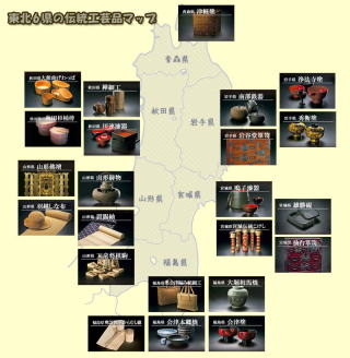 
Tsugaru lacquerware
in Aomori Prefecture |

Tsugaru Kogin embroidery,
in Aomori Prefecture |
Akebi vine work
in Aomori Prefecture |

Tsugaru forged knives
in Aomori Prefecture |
Akita prefecture
Wild cherry birch, fine work |
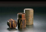
Akita prefecture
Akita cedar wood barrels |
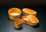
Akita Prefecture
Odate bentwood |

Kawatsura lacquerware,
Akita Prefecture |

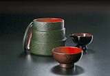
Nanbu ironware
in Iwate Prefecture |
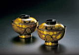
Iwate Prefecture
Hidehira lacquerware. |

Joubouji lacquerware
in Iwate Prefecture |
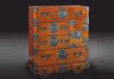
Iwate prefecture
Iwayado (traditional Japanese chest of drawers) |
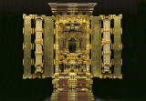
Yamagata Prefecture
Yamagata Buddhist altar |
Yamagata Prefecture
Yamagata Castings |
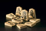
Yamagata Prefecture
Tendo Shogi |
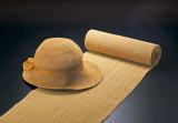
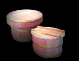
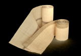
Yamagata Prefecture Ukoshinafu |
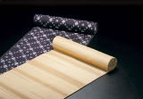
Okitama Pongee
Yamagata Prefecture |
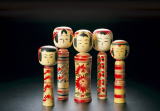
Traditional Kokeshi Doll
in Miyagi Prefecture |
Chest of drawers
Miyagi Prefecture
|
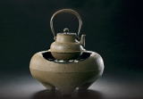
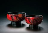
Miyagi Prefecture,
Naruko Lacquerware
|
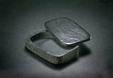
Ogatsu Inkstone,
Miyagi Prefecture |

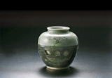
Aizuhongo ware,
Fukushima Prefecture |
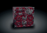
Ohori Soma ware,
Fukushima Prefecture |
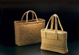
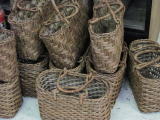
Fukushima Prefecture, Oku-Aizu Braided Work |
Weaving from the Showa era
in Fukushima Prefecture |
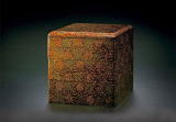
Aizu lacquerware,
Fukushima Prefecture |
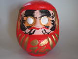
Shirakawa Daruma, Fukushima Prefecture |
▶top page □up |
|
2010/04/20 The homepage is now open.
Topy Planning ltd.
100-467, Toyoura-nakamachi, Nasushiobara-City, Tochigi-ken
325-0063, Japan
tel/fax +81287-62-7673 Cell phone number: +8180-5089-9227 |